Class A - 18,000'MSL to 60,000'MSL (Not depicted in Chart) - Requires Instrument Rating - Enter ATC Clearance
Class B
- 3 Solid Blue Rings Shelves Base & Ceiling Top 10,000' MSL - Required -2 way radio, Transponder with Altitude reporting capabilities (call a Mode C Transponder), - ADS-B OUT - Enter ATC Clearance, "Cleared into Bravo" -Visibility- 3SM - Cloud Clearance- Clear of Clouds (CC) 3/CC
Class C
- 2 Solid Magenta Ring (Inner Ring Surface to 4,000' AGL, 5 miles Radius)(Outer ring 12000' to 4,000' 5 miles Radius) - Required -2 way radio, Transponder with Altitude reporting capabilities (call a Mode C Transponder), - Enter Establish 2 way communication with Tower They must use your callsign) -Visibility- 3SM - Cloud Clearance- (3/152) 500' Below, 1,000' above, 2000' away
Class D
- Dash Blue (Surface to 2500'AGL, 5 Miles Radius) - Required -2 way radio, Enter Establish communication with Tower - ADS-B OUT -Visibility- 3SM - Cloud Clearance- (3/152) 500' Below, 1,000' above, 2000' away
Class E
-Controlled Airspace - Support IFR traffic - Required Equipment (Below 10,000' MSL - None, Above 10,000'MSL -Mode C Transponder With Altitude Reporting) ADS-B out - Enter No requirements
Class G (Uncontrolled)
- Staring Ground to 700'AGL, to 1,200'AGL, to 14,500MSL - Required None - Enter No Requirement 18,000 depicted on Sectional Chart. Special Use Airspace - Prohibit, Restricted, Alert, Special Airport Traffic, ADIZ, Mode C, National Security, TRMS Floor, Ceiling, Lateral Limit
Class BRAVO Busy MSL
3SM Solid Blue Bos, NY, LAX, Miami 10,000' to Ground (ceiling/Shelf) Speed Limit
Class CHARLIE Charter Jet
3SM 4000'AGL x 5MN (MN800' longer than Statu Mile) ATC Permission Solid Magenta
Class DELTA 3SM Dimention: Surface to 2,500' x 4.3NM
A - Altitude - Maintain _______ expect ____________ (5 or 10 depending on departure)
F - Departure Frequency _______
T - Transponder SQUACK _________
----- TRANSITION FROM TOWER TO DEPARTURE -----
Cessna 34Y, Turn left heading 360 - Left 360 , 34Y Cessna 34Y,, Turn left heading 090 - Left 090 , 34Y Cessna 34Y, You are 11 miles from RUKIY Turn right heading 160 Maintain 3,000 until established on localizer Clear ILS Runway 18 approach - Right 160, - maintain 3,000 until establish on localizer - Clear ILS Runway 18 approach 34Y
Cessna 34Y, Contact Tower, 119.3 Have a good day - Tower 119.3 34Y good day
----- TRANSITION FROM APPROACH TO TOWER -----
----- TRANSITION FROM TOWER TO GROUND -----
Bug - Final Approach course on HSI Descend Checklist (Weather, NOTAMS, Approach Tower Ground
CLEARED (type) APPROACH.
CLEARED APPROACH. (To authorize a pilot to execute his/her choice of instrument approach), CLEARED (specific procedure to be flown) APPROACH. (Where more than one procedure is published on a single chart and a specific procedure is to be flown), CLEARED (ILS/LDA) APPROACH, GLIDESLOPE UNUSABLE. (To authorize a pilot to execute an ILS or an LDA approach when the glideslope is out of service) CLEARED LOCALIZER APPROACH (When the title of the approach procedure contains “or LOC”) CANCEL APPROACH CLEARANCE (additional instructions as necessary) (When it is necessary to cancel a previously issued approach clearance)
Clearances authorizing instrument approaches are issued on the basis that, if visual contact with the ground is made before the approach is completed, the entire approach procedure will be followed unless the pilot receives approval for a contact approach, is cleared for a visual approach, or cancels their IFR flight plan.
Approach clearances are issued based on known traffic. The receipt of an approach clearance does not relieve the pilot of his/her responsibility to comply with applicable Parts of Title 14 of the Code of Federal Regulations and the notations on instrument approach charts which levy on the pilot the responsibility to comply with or act on an instruction; for example, “Straight-in minima not authorized at night,” “Procedure not authorized when glideslope/glidepath not used,” “Use of procedure limited to aircraft authorized to use airport,” or “Procedure not authorized at night” or Snowflake icon with associated temperature.
In some cases, the name of the approach, as published, is used to identify the approach, even though a component of the approach aid, other than the localizer on an ILS is inoperative.
Where more than one procedure to the same runway is published on a single chart, each must adhere to all final approach guidance contained on that chart, even though each procedure will be treated as a separate entity when authorized by ATC.
The use of alphabetical identifiers in the approach name with a letter from the end of the alphabet; for example, X, Y, Z, such as “HI TACAN Z Rwy 6L or RNAV(GPS) Y Rwy 04”, denotes multiple straight-in approaches to the same runway that use the same approach aid.
Alphabetical suffixes with a letter from the beginning of the alphabet; for example, A, B, C, denote a procedure that does not meet the criteria for straight-in landing minimums authorization.
14 CFR Section 91.175(j) requires a pilot to receive a clearance to conduct a procedure turn when vectored to a final approach course or fix, conducting a timed approach, or when the procedure specifies “NO PT.”
An aircraft which has been cleared to a holding fix and prior to reaching that fix is issued a clearance for an approach, but not issued a revised routing; that is, “proceed direct to....” may be expected to proceed via the last assigned route, a feeder route (if one is published on the approach chart), and then to commence the approach as published. If, by following the route of flight to the holding fix, the aircraft would overfly an IAF or the fix associated\ with the beginning of a feeder route to be used, the aircraft is expected to commence the approach using the published feeder route to the IAF or from the IAF as appropriate; that is, the aircraft would not be expected to overfly and return to the IAF or feeder route.
Approach name items contained within parenthesis; for example, RNAV (GPS) Rwy 04, are not included in approach clearance phraseology.
Pilots are required to advise ATC when intending to apply cold temperature compensation to instrument approach segments. Pilots must advise ATC of the amount of compensation required for each affected segment on initial contact or as soon as possible. Pilots are not required to advise ATC when correcting on the final segment only. Controllers may delay the issuance of an approach clearance to comply with approved separation requirements when informed that a pilot will apply cold temperature compensation (CTC). Pilots will not apply altitude compensation, unless authorized, when assigned an altitude prior to an approach clearance. Consideration should be given to vectoring aircraft at or above the requested compensating altitude if possible. This eliminates pilots having to climb once on the approach.
REFERENCE-
FAA Order 8260.3, United States Standard for Terminal Instrument Procedures (TERPS). P/CG Term - COLD TEMPERATURE COMPENSATION. AIM, Para 5-1-17, Cold Temperature Operations. AIM, Para 5-5-4, Instrument Approach.
There are some systems, for example, Enhanced Flight Vision System (EFVS), which allow pilots to conduct Instrument Approach Procedures (IAP) when the reported weather is below minimums prescribed on the IAP to be flown.
REFERENCE-
14 CFR § 91.175(l). P/CG Term - EFVS.
For aircraft operating on unpublished routes, issue the approach clearance only after the aircraft is:
Established on a segment of a published route or instrument approach procedure, or (See FIG 4-8-1)
EXAMPLE-
The aircraft is established on a segment of a published route at 5,000 feet. “Cleared V‐O‐R Runway Three Four Approach.”
There’s little that’s more essential to an instrument pilot than the approach clearance. We controllers issue them all day long. I fully expect much of my frequency time to be spent issuing approach clearances for either training flights or weather-related needs.
Routine or not, an approach can have a lot of nuances. Its sole purpose is to safely get an aircraft from the air to the ground in bad weather. The pilot is busy managing everything to fly that approach. My job as a radar controller is to make your job as successful and effortless as possible. After all, you’re the one in the soup, not me….
When I first started training on radar, my instructors beat a simple acronym into my head: PTAC, pronounced “P-tack.” That little term reminded me of all the required core elements in a good approach clearance: position, turn, altitude, and clearance. Each of those components and ATC regulations contribute to getting you to the runway via a stable approach.
Close Enough
The “position” part is easiest: issue the pilot’s distance from a point on the approach. That fix could be an IAF, FAF, a navaid used for the approach, or the airport itself.
Keep in mind that we’re usually “eyeballing” this distance. While our radar does have tools allowing us to measure precise distances, we often simply don’t have time to use them. We rely instead on mileage “tick marks” drawn on our radar maps. Each mark is either a mile or half a mile, depending on the facility.
Over time, we develop an eye for it, but it’s still an estimate. We’re gauging moving objects, affected by varying winds, tracked by radar that’s a few seconds behind. So, if you’re showing you’re 3.6 miles from the FAF, and ATC says, “three miles from [FAF name],” it’s okay. Obviously, if it’s off by a significant amount, or they say the wrong fix, question it.
I’ll add that this particular rule was written long before GPS. The fact is, with the tools in modern cockpits you probably know exactly where you are. However, we still give the distance to enhance situational awareness for those without the fancy toys.
Terminal Arrival Areas (TAA)
Terminal Arrival Areas (TAAs) make a controller’s life a bit easier, and can greatly simplify the clearance. In the TAA, the PTAC “T” is a clearance direct to the IAF. The “A” is built right into the chart. So, according to the 7110.65 paragraph 5-9-4 (e), the controller just needs to give a position and issue the clearance.
In this example image from FAA Order 7110.65, we have three aircraft to clear via TAAs. Assume they’ve already been cleared direct to their relevant fix and their turn to final isn’t over 90 degrees. Aircraft 1: “Proceed direct CENTR. Seven miles from CENTR. Cleared RNAV Runway one eight approach.” Aircraft 2: “One five miles from LEFTT. Cleared RNAV Runway one eight approach.” Aircraft 3: “Thirty-six miles from RIGHT. Cleared RNAV Runway one eight approach.”
Per the Instrument Procedures Handbook, “Once cleared for the approach, pilots may descend in the TAA sector to the minimum altitude depicted within the defined area/subdivision, unless instructed otherwise by air traffic control. Pilots should plan their descent within the TAA to permit a normal descent rate from the IF/IAF to the FAF.”
This TAA is specified by the three arcs extending 30 miles from each fix. Once cleared for the approach, the pilot is expected to maintain any previously assigned altitude until inside that arc. Aircraft 1 and 2 could start their descent immediately to the TAA sector’s altitude, 3000 feet in this case. Aircraft 3 would have to wait until it’s inside 30 miles from RIGHT.
TAAs have caused confusion for both pilots and controllers. A little extra verbiage might ease the mind. If there’s traffic or another concern below Aircraft 3 prior to it entering the sector, a controller may emphasize, “Maintain 4000 until inside the TAA.” It wouldn’t be a bad idea for the pilot to state, “Leaving 4000 for 3000,” when starting descent. The Handbook has a lot more info on TAAs.
Turn it Up
Now we’ve got an idea of your position. How are you getting from there to the approach? ATC can either clear you via an initial approach fix, or via radar vectors to a portion of the approach. Those direct “fix” clearances or headings must, again, be issued in compliance with ATC rules.
For “fix” clearances via an IAF, we must first tell you to proceed direct to the fix in question and issue an altitude to maintain until you cross that fix. “Seven miles from FIXXX. Proceed direct FIXXX. Cross FIXXX at 3000, cleared RNAV Runway 18 approach.” However, ATC must remain cognizant of the kind of turn you must make when you hit that fix and need to turn towards the approach. Some approaches have procedure turns built-in, allowing you to hit that fix from any angle, make the PT, and come back in on the approach.
However, if we’re expecting you to proceed directly to the IAF and turn on to the approach straight-in we must ensure that turn to the approach course is no more than 90 degrees. Just the hard 90-degree turn on its own can be tough for some pilots to manage, resulting in spill-outs and corrections. Making a sharp U-turn isn’t at all conducive to a stable approach.
That same desire for a stabilized approach guides the FAA’s controller regulations for issuing vectors to final. Whereas clearances via IAFs have 90 degrees of leeway, vectors to a final approach course have much tighter tolerances, since you may be joining well inside any IAFs.
These vectors are based on an imaginary point called the “approach gate.” Take a look at any final approach fix. The approach gate is one mile out from the FAF. Per the Pilot/Controller Glossary: “The gate will be established along the final approach course 1 mile from the final approach fix on the side away from the airport and will be no closer than 5 miles from the landing threshold.” That’s a mile from the FAF or five miles from the threshold, whichever’s further out.
If our vector has you intercepting between zero and two miles from the gate (i.e. within three miles of the FAF), we can’t use more than a 20-degree intercept angle. For an ILS whose localizer is 090 degrees, intercept headings are between 070 and 110. For an intercept over two miles from the gate, we can use up to 30 degrees (060-120 in the example), since you have more time to get established.
In some cases we aren’t allowed to intercept inside two miles from the gate. Weather is one. We must add the extra mileage if the ceiling is less than 500 feet from our Minimum Vectoring Altitude or the visibility is less than three miles—getting extra time to get stabilized is helpful. Also, vectors to final for an RNAV approach gets the added distance, in part to allow the GPS time to verify it’s captured the approach properly and increase sensitivity.
Can you be vectored closer than the approach gate? Yes, but you need to ask for it. In section 5-9-1 (a) of the 7110.65—it says: “If specifically requested by the pilot, aircraft may be vectored to intercept the final approach course inside the approach gate but no closer than the final approach fix.” Basically, if you ask for it, I can vector you directly at the FAF. This doesn’t apply to RNAV approaches for the reason listed earlier.
Confirm the Concrete
Does the runway always have to be part of an approach clearance?
Not necessarily. Given that an approach’s purpose is to get you to a runway, shouldn’t ATC always specify that runway in the clearance? Actually, the 7110.65 allows us to skip saying the runway if there’s no runway ambiguity.
For instance, if an airport has an ILS Runway 9 approach, but three RNAV approaches to other runways, I don’t have to state “Runway niner” if I clear you for the ILS—position, turn, altitude, and “Cleared ILS approach.” If there’s only one ILS, logically that’s the only one you can fly. However, I’d need to define the runway if I clear you for an RNAV approach, since there are three possible choices.
If I’m feeling especially carefree, I don’t even have to say the approach name. “N123AB, one zero miles from [airport]. Cleared approach.”
Per the Pilot/Controller Glossary, “cleared approach” grants “ATC authorization for an aircraft to execute any standard or special instrument approach procedure for that airport.” You have permission to fly any approach you want to that airport. Want an ILS? An RNAV? An NDB? Do what you want.
AIM 5-4-7 (e) provides more guidance: “…pilots must execute the entire procedure commencing at an IAF or an associated feeder route as described on the IAP chart unless an appropriate new or revised ATC clearance is received, or the IFR flight plan is canceled.”
Now, the glossary does throw some cold water on the proceedings: “Normally, an aircraft will be cleared for a specific instrument approach procedure.” In the real world, most controllers simply have too much traffic to write a blank check and let the pilot go nuts. But, it can happen if it’s quiet out there. —TK
Keeping Your Lunch
Obviously, we can’t let you descend before it’s safe. Per 7110.65 5-9-4 (c) we must, “Issue approach clearance only after the aircraft is … assigned an altitude to maintain until the aircraft is established on a segment of a published route or instrument approach procedure.”
The route of an instrument approach has been checked and ensured to be clear of obstacles and terrain. However, until you are established on that approach, ATC must ensure you stay above those threats.
So, we assign an altitude equal to or above the IAF’s altitude, which you are expected to maintain until established on the approach. “Maintain 3000 until established on the localizer.” Or, “Cross FIXXX at or above 3000.” Once you meet those conditions, you’re safely in TERPS-designed territory and can descend on the approach profile.
That “at or above” restriction must consider aircraft performance and permit a stabilized approach. Expecting a pilot to drop 5000 feet in five miles won’t work. Controllers have to plan ahead and—like the turns to final—descend the aircraft early enough to put it in good position for the approach.
Altitude is also used for traffic separation. Imagine you’re holding over an airport’s VOR at 3000 feet, requesting a VOR approach with a full procedure turn. Traffic is inbound, descending out of 2000 on the same approach. I can tell you, “Proceed outbound on the VOR approach; maintain 3000,” without an approach clearance. You’re cleared for the approach’s plan view, but not the vertical profile, instead holding 3000.
You’re outbound at 3000. The other guy is inbound at 2000 on final. If you start your descent now, you’ll drop right into him. But, you’re outbound for the procedure turn. As long as you don’t descend before then, you’ll both be safe. So, I’ll just say, “Maintain three thousand until procedure turn inbound. Cleared VOR Runway one eight approach.” Using good timing and altitude control, we can work traffic more efficiently.
Commencing Clearance
We’re now left with the clearance itself. Naturally, the clearance has multiple parts. We start with the word “cleared.” This is followed by the approach’s title, the runway (if applicable), the word “approach,” and then any circling instructions. We’ll only state the approach’s title that’s outside parentheses, so no “GPS” for an “RNAV (GPS)” approach.
We’ll also include the term “straight-in” if we don’t want you to fly any published procedure turn. Any time the intercept angle is 90 degrees or less, we’ve got to say “straight-in” if we don’t want a course reversal. This is important.
There’s often other traffic, and if you unexpectedly fly a procedure turn, things could get ugly. Here’s a tip: unless you and the controller have already, explicitly discussed the procedure turn or used the term “full approach,” confirm with ATC. “Approach, do you want a straight-in approach, or a procedure turn?” At times, procedure turns are prohibited (“NoPT”).
Of course, there are approaches with no straight-in runway and no runway in their title. They have only circling minimums and are named with a letter (VOR-A, RNAV-B, etc.). Commonly, the approach isn’t aligned within 30 degrees of a runway. It might require an unusually high descent rate, or the runway lacks sufficient marking or differentiation to meet straight-in requirements.
With a standard circling approach, the circling instruction will be the approach clearance’s final instruction: “Cleared VOR Runway two seven approach, circle Runway one eight.” For a “letter” approach, instead of stating a runway associated with the approach—since there isn’t any—we’ll just state the runway of intended landing. “Cleared RNAV B approach, Runway one eight.”
So, let’s fire off some PTAC. Requesting an ILS to Runway 9? “N782RT, six miles from [FAF]. Fly heading 130. Maintain 2500 until established on the localizer. Cleared ILS Runway niner approach.” Requesting the RNAV (GPS) Runway 18 with a circle to Runway 9? Oh, and the RNAV has a published procedure turn? “Eight miles from [IAF]. Proceed direct [IAF]. Cross [IAF] at or above 3000. Cleared straight-in RNAV Runway one eight approach. Circle to Runway niner”.
While there are other nuances, beginning with effective use of the basic pieces—position, turn, altitude, and clearance—ATC can help you safely and comfortably get down to the ground.
FAA is transitioning to ICAO for ALL flight plans – international AND domestic, that is the format everyone needs to learn. In addition, filing electronically through the 1800WXBRIEF.com website or DUATS or ForeFlight or similar app will also be the new standard.
1. Always file to the fix on the approach you planning to shoot
2. Always assume you're going Missed (Published Missed or What ATC gives you)
3. Brief your plates on the Ground.
File a Flight Plan
Clearance CRAFT
Fly DP
En Route
Fly Heading
Holding on Fix /Intersection/
ATIS/Approach/Tower/Ground
Briefing Approach/
initial Approach Fix (ATC vector to IAF)
Fly Approach STAR
Close Flight Plan
VNAV LNAV VERTICAL /LATERAL Guidance
IMC
2 VOR (Cross Radial to locate where you are)
ILS - Localizer
LORAN DME GPS
Privileges of an Instrument Rating
Regency of IFR experience required to act as PIC under IFR rules Logged experience requirements for the IFR check ride
Weather Planning “What’s the difference between the forecast weather?” [… and what?] Explains TAF, AF, Prog chart, Lifted index chart “Do we have any SIGMETs or AIRMETs today?” “Will we have any fog today?” Icing hazards Winds aloft In-flight weather resources
Careful planning for a flight on instruments is important. Besides satisfying normal IFR requirements, an instrument pilot flying in clouds or at night must be conscious of high terrain or obstacles that cannot be seen, and ensure that a safe altitude above them is maintained. You must be aware of the danger of icing (both airframe and carburetor icing) and take appropriate precautions; you must have an alternate airport in mind in case a diversion becomes necessary; and you must have sufficient fuel to get there, and still have a safety margin remaining in the tanks on arrival.
The best time to organize these things is prior to flight.
Compile a flight log with courses, distances, times, MEAs and cruising altitudes calculated.
Compile a fuel log, with adequate fuel reserves.
File an IFR flight plan.
Prepare the airplane.
Organize the cockpit for flight—select charts, ensure that a flashlight is kept handy for night flying, etc.
Brief passengers.
To operate in controlled airspace (Classes A–E) under IFR, you are required to:
file an IFR flight plan (usually done in person or by telephone to FSS or ATC on the ground at least 30 minutes prior to the flight); and
obtain an air traffic clearance (usually requested by radio immediately prior to departure or entering controlled airspace).
The 30 minutes is required to allow time for ATC to process your flight data and (hopefully) avoid delays to your flight. The preferred methods of filing a flight plan are: in person by telephone or by DUATs — by radio is permitted, but discouraged because of the time it takes. Closing a flight plan by radio is typical because it takes just a few seconds.
Closing an IFR flight plan is automatically done by ATC at tower-controlled airports after landing. At an airport without an active control tower, you must close the flight plan with FSS or ATC by radio or telephone. Do this within 30 minutes of the latest advised ETA, otherwise search and rescue (SAR) procedures will begin.
An IFR flight plan is required in both IMC and VMC in Class A airspace, and in IMC conditions in Classes B, C, D and E (controlled) airspace (and also in VMC, if you want to practice);
An IFR flight plan is not required in Class G (uncontrolled) airspace.
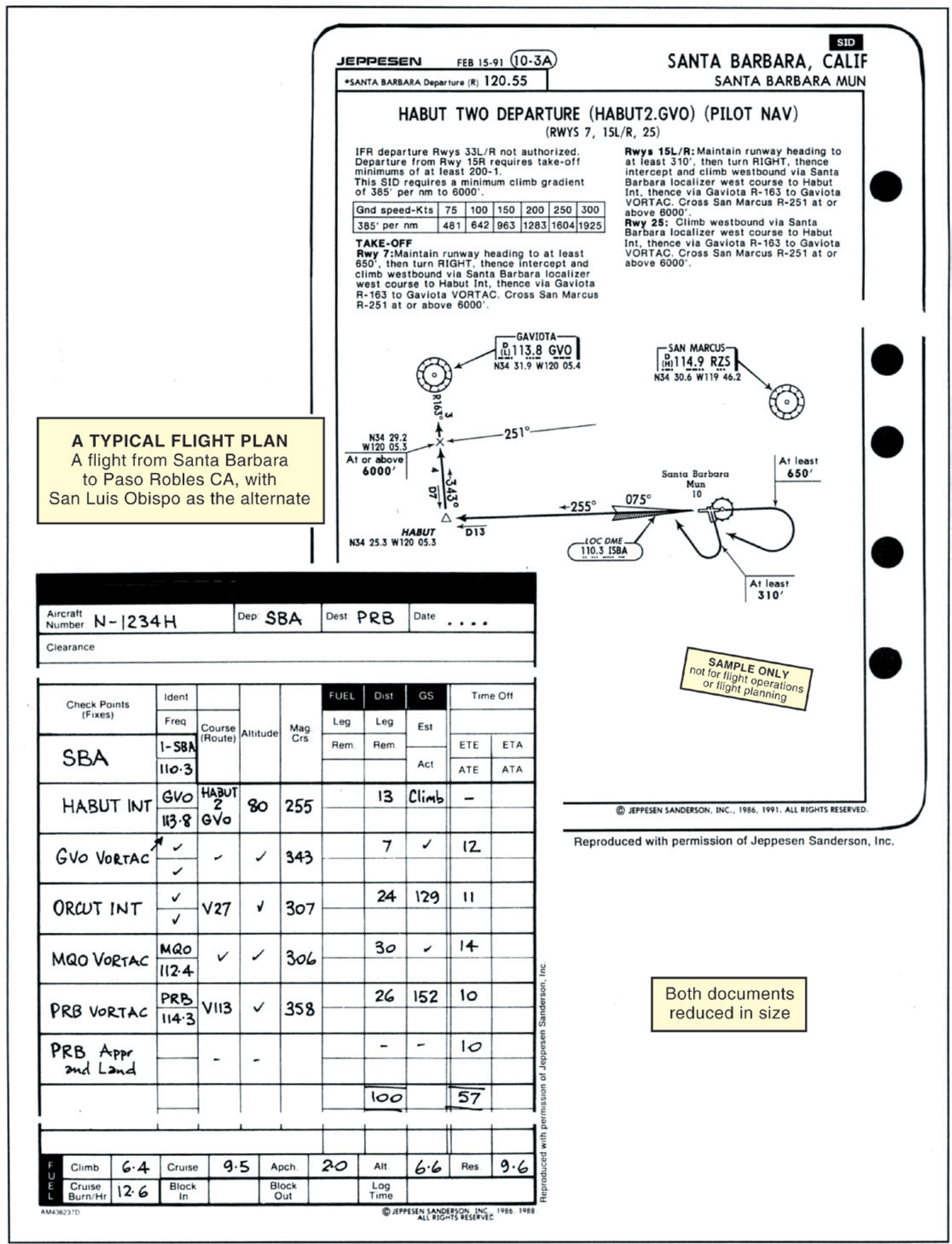
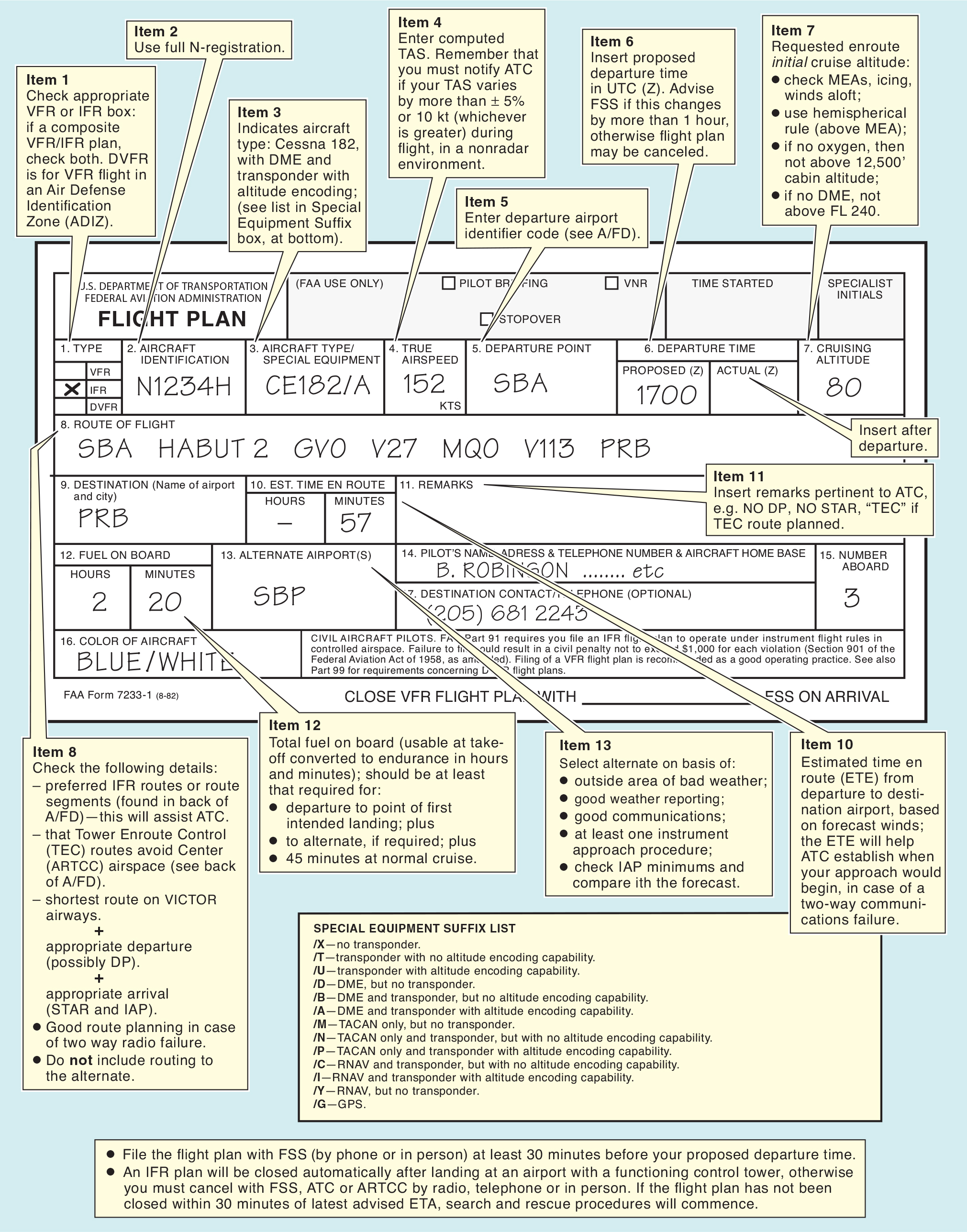
To assist you in completing the flight plan and performing the flight, you should compile a navigation log, calculating time intervals and fuel requirements. A typical navigation log is shown in figure 1, and a typical flight plan form is shown in figure 2.
Figure 1.Click for full-size.
Figure 2.Click for full-size.
Important navigation log items to be inserted on the flight plan include:
the planned route;
the initial cruise altitude or flight level (later altitudes or flight levels can be requested in flight);
the estimated time en route (ETE), in hours and minutes, from departure to touchdown at the first point of intended landing;
the total usable fuel on board at takeoff, converted to endurance in hours and minutes.
If you wish to fly part of the route according to IFR procedures and part according to VFR procedures, you can file a composite flight plan, signified by you checking both IFR and VFR in the Item 1 box on the flight plan form. You should also indicate the clearance limit fix in the flight-planned route box, to show where you plan to transition from IFR to VFR.
8:45 Pizza at destination 8:54 Fuel planning considerations 9:41 “Minimum fuel” notification to ATC vs. fuel emergency 10:27 Flight route review on charts 11:40 IFR Chart symbology 12:34 How to determine preferred routes 13:18 Elements of an IFR flight plan 13:54 Procedures to activate and close a flight plan 15:15 Ryanair cabin crew bikini calendar 15:40 Oxygen requirements 16:25 Altitude and course requirements 17:05 Pre-flight requirements 18:32 Visibility requirements 19:06 “Can we fly through a TFR?” 19:31 Alternate requirements 22:25 Define RAIM? [correction: “receiver autonomous …”, not “radio autonomous …”] 24:20 Human factors affecting a go/no-go decision 25:30 Areas unsuitable for landing 26:35 Aircraft systems required for VFR and IFR operation 27:55 De-icing and anti-icing equipment on small planes 29:12 Instrument failures 30:07 Do we need a compass for this flight? 30:22 Do we need a transponder for this flight? 30:36 Navigation instruments 31:04 Flight Instrument Failure Modes 32:08 Approved vs. non-approved navigation devices 33:19 Explain PFD and MFD 34:43 How to deal with inoperative equipment 34:49 Loss of navigational equipment during an IFR flight 35:12 When is it safe to program navigational equipment 36:02 IFR equipment checks during taxi 36:36 Currency of GPS database 37:12 Runway incursions; explain hotspots 37:44 Obtaining the clearance 38:52 Combined ground/clearance delivery frequencies 39:18 PIC responsibility/authority with reference to accepting clearances 41:14 Clearance readback requirements 41:52 PIC emergency authority 42:39 Purpose of “expect” information 43:18 Lost communications procedures 45:16 Instrument departure procedures 47:57 Clearance void time 49:37 Closing a flight plan at a non-towered airport 50:18 Pop-up IFR clearances 51:16 IFR in a non-radar environment 52:06 Terrain collision avoidance 52:40 CDI deflection limits at which to go missed HOLD Purpose of Holding Procedures Mandatory reports at holds Holding entry procedures Protected vs. non-protected side of the hold Speed limits in holds Side of the holding pattern Turns in a holding pattern Fuel recomputation associated with a hold Wind corrections in a hold Use of an autopilot in a hold Fly by reference to the instruments Spatial disorientation Optical illusions Normal vs. abnormal instrument indications Instrument cross-check Physiological factors associated with flight in unusual attitudes Recovery procedures from unusual attitudes Intercepting and tracking a DME arc Indications of navigational system failure
1:06:47 Precision vs. non-precision approach symbiology 1:10:52 Explain how to perform a procedure turn 1:11:21 Airport diagram symbiology 1:12:25 FAF to MAP timing 1:13:19 Approach chart profile view 1:15:20 Approach categories 1:15:59 Limitations of non-precision approach 1:16:28 Types of minimums in RNAV approach 1:17:17 Annunciations produced by the GPS navigation system during flight 1:18:21 What to look for in a missed approach
Current And In Hand - Sectional Charts - US Chart Supplement (formally AFD) - FAR/AIM - Written Passed (official) IACRA - ACS (Airman Certificate Standard) (Formally PTC) (senarno Base) - View Limiting Device - Headset IACRA Complete (Your CFI should do this 8710 form)
Pilot Documents:
1. Student Pilot Certificate
2. Photo ID
3. Medical Certificate - Valid for .. Class D
- Basic Med
Temporary Airman certificate - issue if you pass the Checkride
LogBook (Pilot) - Flights, instructions, Takeoff/Landing/Endorsements - Requirements Met (Experience met - For day, night, hood time, cross country, solo time, - All Endorsements (From Instructor solo, knowledge test, TSA Security Endorsement - Hours Add up Correctly (Addup solo time/PIC time
Private Pilot Endorsements See AC 61-65E Before Training Citizenship eligibility Endorsement Solo Pre-Solo Aeronautical knowledge test corrected Student pilot certificate make/model Flight training proficiency in logbook for make/model Additional 90 day solo endorsement (if 3 above is not current) Cross-Country Student pilot certificate for category Logbook cross-country training make/model Individual cross-country flight review Possible extra endorsements One time for take-offs/landings less than 25 nautical miles Repeated solo cross-country within 50 nautical miles Solo at night (within previous 90 days) Solo in Class B Solo to, from, or at an airport in Class B airspace Practical Test FAA written test endorsement Prepared for practical test including deficient FAA written subjects NOTES: Complete the TSA Security Awareness Training online course and print/sign/keep the certificate of completion. Flight Training as defined by:Part 61 says, “training other than ground training by an authorized instructor” 49 CFR Part 1552: “instruction received from a flight school in an aircraft or aircraft simulator. Flight training does not include recurrent training, ground training, a demonstration flight for marketing purposes, or any military training provided by the Department of Defense, the U.S. Coast Guard, or an entity under contract with the Department of Defense or U.S. Coast Guard.”
Aircraft Inspection (to be current to fly)
---------------------
3 Types of Log Books
1. Engine - 100 hrs and Annual inspections, AD
2. Airframe - Elt, Transponder, AD
3. Propeller
For Hire
100 Hr
ELT - same time of
Transponder - 24 calendar month
AD - Airworthiness Compliances
TAC Time not HOB's Time
If something is NOT in compliance can you still fly the aircraft?
LOGBOOK (Aircraft) Required Inspections
AVIATES
AD's - mandatory (all airworthiness directive MUST be complied with)
VOR - 30 Days check (for IFR)
Inspection
- Annual 12 Calendar months - IA Sign-off
-100 hours A&P Sign-off (if aircraft used for compensation or hire)
Altimeter, Transponder and Pitot Static Checks are all done altogether 24 months and same logbook entry
An Annual Inspection can be used in stead of an 100 hrs inspection, but 100hr inspection CANNOT be substitute an Annual Inspection.
TSMOH
TACH - Tachometer
TSN - Time Since New
FAA requires All US Registered civil aircraft must undergo an annual (12 Calendar) months inspection
The regulations require that all maintenance be appropriately documented in the aircraft’s logbooks. This applies to owner maintenance as well. Any time you perform maintenance, you must log the following:
The type of inspection and a brief description of the extent of the inspection; The date of the inspection and aircraft total time in service; The signature, the certificate number, and kind of certificate held by the person approving or disapproving for return to service the aircraft, airframe, aircraft engine, propeller, appliance, component part, or portions thereof. A typical oil change entry would be entered in the engine logbook as follows:
8/23/15 3025TT Airframe, 1222 SMOH Engine Drained oil and replaced with 7qts. 20W50 Oil. Replaced 48110 oil filter and safety wire. Collected oil sample for analysis. Engine test-run and no leaks noted. Jeffrey Simon Owner, pilot license #11223333
Aircraft Documentation
SPARROW -
S-Supplements
P- Placard (modifications) how to use the system in systems for modifications -
A Airworthiness Certificate FAR 91.203 - Valid as long as aircraft is maintained and an airworthy State - Must be visible to crew & passenger
RRegistration FAR 91.203 - Registrated to the Owner
- Matches the Aircraft you'll be flying - Pink Copy: 90 Days Authorization for operation in US Only
RRadio License - Required if you are flying international - Issued by the FCC
OOperating Handbook FAR 91.9 Plack
WWeight and Balance Basic Empty Weight - Basic Empty Weight FAR Part 23 FAR 91.103
Oral Review
1. 2 years (24 Calendar months) Bi-Annual Fly Review 2. Currency - 61.57 - 3 take off and landing in the past 90 day, Night Full stop with 6 month 6 months wouthout flying
3. 14CFR1.1 Night Time: Civil twilight 1 hr after sunset, 1 hr before sunrise eg sunset 5PM - Cicil Twilight 5:26 - 1 hr after sunset 6PM 4. Proficiency/Currency 5. If Winds 10 gusting 15 -
6. What kinds document you need to fly ARROW License Identification Photo ID Medical Certificate ARROW Airworthiness certificate Registration (temporary is pink) (every 3 years on actual certificate valid -Notify of AD) Radio license (international flights) Operation handbook Weight & balance
AVIATES Annual (12 months) IA sign off VOR Check (30 Days) 100 Hour or Progressive inspection (required if aircraft is used for hire or flight instruction for hire—91.409(b)) - Ferry Permit from FISO if 100 hr expire and take aircraft for 100hr inspection AMP sign off Altimeter (24months 91.411) and Airworthiness Directives (every 2 weeks published) Working with Machenic, look in log book Transponder (24 months 91.413) ELT (12 months - Battery replace 50% of life in use, more 1 hour ) 121.5 to listen of ELT, Maintance logs Static inspection (24 months) Owner POC - Maintaince Log
7. Cross country Planning Weather - Metar PALH 261853Z 15004KT 10SM CLR M24/M27 A2933 RAM A02 SLP932 T12391272 It's a METAR Date & Time 26th 1853Zulu Winds 150deg at 04KTs Visibilit 10SM Cloud CLR Clear Temperature /Duepoint temp -24deg duepoint-27deg M24/M27 Altimeter 29.33 Remarks RMK Automated A02 SLP932 T12391272 Sensor A02 Type of Sensor at station can distinguish between rain & snow. A01 cannot Sea Level Pressure SLP932 Temperature duepoint spread -23.9 and -27.2 T12391272 * When temp and due point equal - have fog/Cloud - Poor visibility
TAF (terminal Area forecast 5 stactu miles from airport) No Temps on TAF PANC261720Z 2618/2724 36006KT p6SM SKC FM270400 35012KT P6SM FWW100 SCT200 FRM271900 36007KT P6SM VSCH BKN060
2618/2724 - 26th 1800Zulu to 27th 2400Zulu (about 30hrs for good weather) Winds North at 6knots Visibility 6SM SKC Sky Clear FM270400 35012KT P6SM FEW100 SCT200 From 27th at 0400Zulu Winds 350degs at 12knots 35012KT Visibility 6statue miles P6SM Clouds FEW100 Few 10,000' and Scattered 20000 SCT200
FM271900 36007KT P6SM VSCH BKN060 From 27th at 1900Z Winds 360deg at 7knots 36007KT Visibility 6statue mile Shower in visitity VSCH Clouds broken at 6000' BKN060 FM270200 14013G20KT P6SM -RA SCT015 OVC025 WS020/15040KT on 27th 0200Zulu Winds 140deg at 13Knots gustion 20Knots visibility 6statu miles Rain Shower Cloud Scattered 1500' Overcast 2500' WS02000 - Wind shift at 2000' Winds 150 at 40Knots Turbulant air expect
MEL - Minimum Equipment List https://www.youtube.com/watch?v=WFqxFbTJqKQ&t=198s
DO NOT STALL, CONTROLL YAW SLIP (Cross control maneuvers) - Side Slip - Hold airplane position over center line when making a crosswind landing (left aeleron, Right Rudder) for left crosswind - Forward Slip - crab attitude, Use to lose altitude, increase visibility of runway - Wind 30def from left @17knots, Longitude axis is at an angle of runway, nose into wind, power at idle (Right aeliron, Left rudder)
What version of slow flight do you like to see * PTS - Stall warning horn * ACS - NO stall warning horn 3 ways in your real world day how you prevent runway incursion? - Write down & read back - Taxi Diagram - Zoom in
Think out loud 5 Examiner - Checkride Question ------------------------------- 1. An AFT CG=? Is it faster or slower Cruise Speed? More stable or Less Stable Aircraft? AN AFT CG ALLOWS FOR FASTER CRUISE BUT FRAR LESS STABLE AIRCRAFT (Less Tail Down Force) AFT (move back CG, Less effective)
2. Give me 2 Reason why A pilot MUST flile a Flight Plan? - Crossing over an ADIZ (International Flying) - When Weather condition requires it (IFR)
3. You're flying and a Circuit breaker Pops, How many time can you rest it & How long should you wait before you reset it? Once & Wait one minute If it not your primary flight instrument you can live without you eg NAV radio 1
4. You're on Takeoff passing through, 1,000FT and Approaching a Few birds. What should you do? If able get above them. Know that Birds have a tendency to dive when frightened
5. What is the First Instrument you look at when recovering from Spatial Disorientation ANSWER: AIRSPEED Indicator - Airspeed Indicator (too slow stall, too fast stress bring power back) NOT the Attitude Indicator (reliable up to 59 deg, 60deg and beyond it will tumble and no longer accurate)
A02 means that the site is automated and HAS a precipitation sensor. If it were AO1, there would be no precip sensor.
Supplementary Information RE = Recent weather followed by weather codes WS = Windshear, followed by: TKOF/LDG (takeoff/landing) RWY (2 digits runway identifier and designator L/R/C) RMK = Remark SLP = Sea Level Pressure T00221083 (Expanded temp/dewpoint) 1st, 5th digits: 0=plus, 1=minus 2nd-4th digits: temp (decimal missing) (02.2) 6th-8th digits: dewpoint (decimal missing) (-8.3)
KBOS Boston 040954Z Date 04th Time 0954zulu (5:54AM) 04011KT Winds 040 at 11knots 7SM Visibility 7statue Miles RA Conditions - Raining OVC008 Cloud cover overcast at 800' 09/07 Temperature 09deg C; Dewpoint 07 A2978 Altimeter 2978 RMK Remarks AO2 Automated Weather Station - A02 means that the site is automated and HAS a precipitation sensor. If it were AO1, there would be no precis sensor SLP083 Sea Level Pressure P0008 T00890067 Expanded Temperature & Dewpoint 0 + 08.9 + 06.7
RNAV - - Approach Clearance is Turn /Direct to a fix, the Altitude and the clearance.
PTAC - Position, Turn, Altitude, Clearance
Precision Approach
Non-Precision Approach
Localizer or VOR
Localizer
No vertical guidance
Step down fixes
DEM distance for the localizer.
The fixes such as ELUCO and BENDR (Profile View of Approach) with minimum altitudes, these are call step-down fixes.
1. Be ahead of the aircraft.
Radar Vectors to Final Clear for the ILS Clearing for the approach Intercept Altitude to hold Heading speed Victor to Intercept clearance ------------------------------ Expect Vectors to Intercept -------------------------------- https://www.youtube.com/watch?v=t8PD8c81lvA
PHAC.. the controller is going to give you your POSITION, HEADING, ALTITUDE, and CLEARANCE.. and the pilot only needs to respond with the HAC portion.. HEADING, ALTITUDE, and CLEARANCE. Position (miles to a certain fix) Instruction - Maintain heading, descend to altitude Clear to approach - Then ask you to contact tower at frequency Pilot: Austin tower, Cessna 34H establishing on ILS 36R


